
You can find on this page the map of Madrid bus and the map of Madrid night bus Búhos. Madrid buses are a transit system serving the city of Madrid (Spain) with the subway, the urban, suburban & commuter train or the tram. The bus & Búhos network has 244 lines (217 regular bus / 27 night bus) and more than 10,000 stops forming a bus network of 2,293 miles (3,690 km).
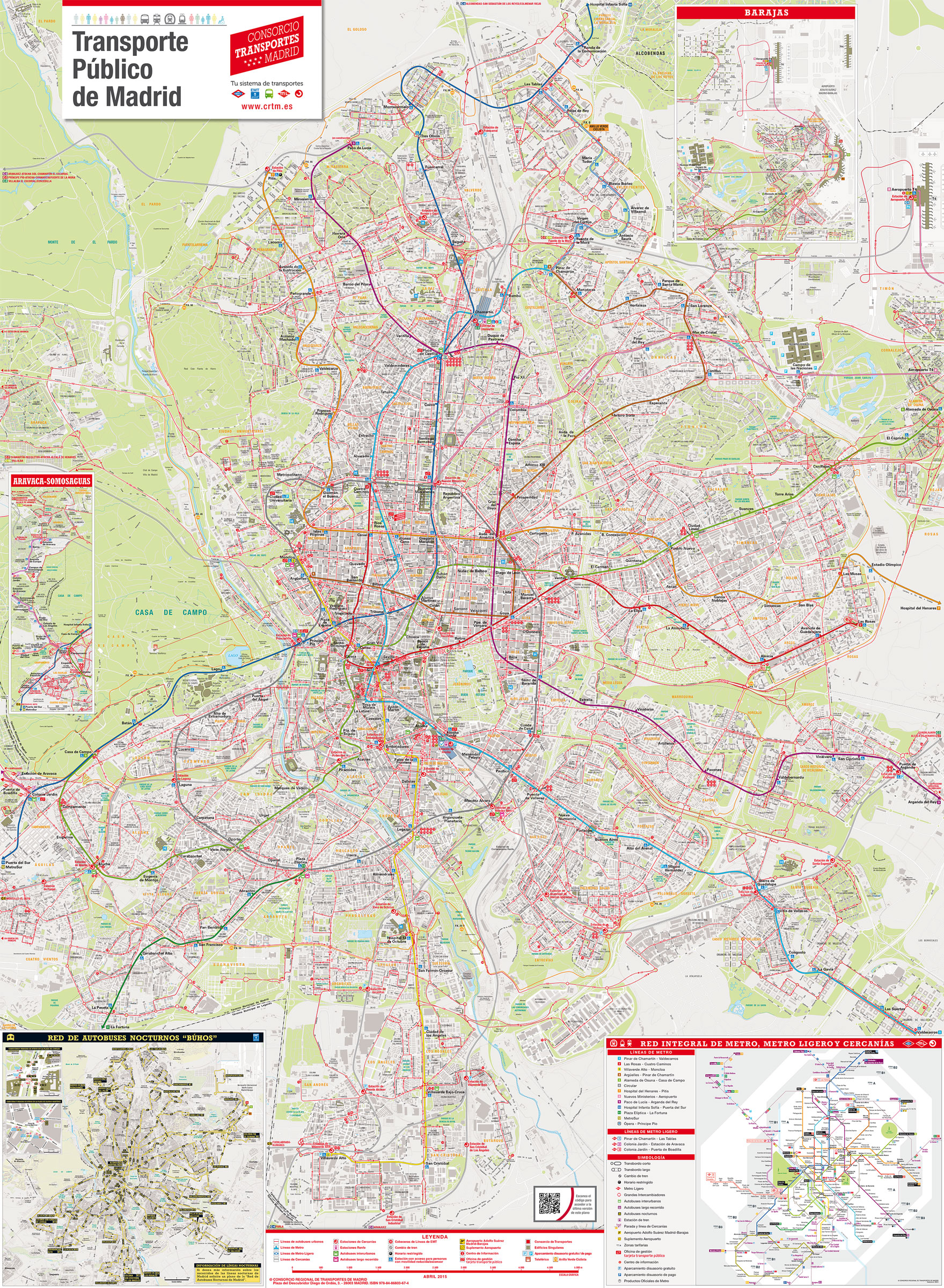
Madrid bus network is operated by the EMT (Empresa Municipal de Transportes) and includes 214 lines (red and blue bus) but also suburban buses (green bus) or airport express bus (yellow bus)
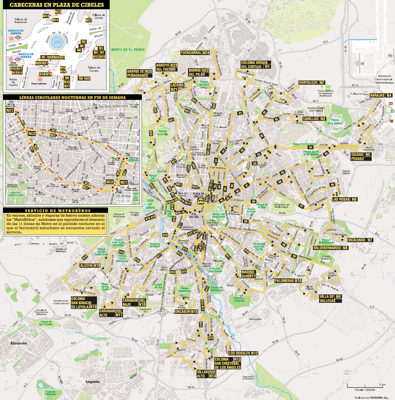
The Búhos night bus network of Madrid is operated by the EMT (Empresa Municipal de Transportes).
Its network includes the following 27 lines:
• Line N1: Plaza de Cibeles ↔ Sanchinarro
• Line N2: Plaza de Cibeles ↔ Hortaleza
• Line N3: Plaza de Cibeles ↔ Canillas
• Line N4:Plaza de Cibeles ↔ Barajas
• Line N5: Plaza de Cibeles ↔ Colonia Fin de Semana
• Line N6: Plaza de Cibeles ↔ Las Rosas
• Line N7: Plaza de Cibeles ↔ Vicálvaro
• Line N8: Plaza de Cibeles ↔ Valdebernardo
• Line N9: Plaza de Cibeles ↔ Ensanche de Vallecas
• Line N10: Plaza de Cibeles ↔ Palomeras
• Line N11: Plaza de Cibeles ↔ Madrid Sur
• Line N12: Plaza de Cibeles ↔ Los Rosales
• Line N13: Plaza de Cibeles ↔ Colonia San Cristóbal de los Ángeles
• Line N14: Plaza de Cibeles ↔ Villaverde Alto
• Line N15: Plaza de Cibeles ↔ Orcasur
• Line N16: Plaza de Cibeles ↔ Avenida de la Peseta
• Line N17: Plaza de Cibeles ↔ Carabanchel Alto
• Line N18: Plaza de Cibeles ↔ Aluche
• Line N19: Plaza de Cibeles ↔ Colonia San Ignacio de Loyola
• Line N20: Plaza de Cibeles ↔ Barrio de Peñagrande
• Line N21: Plaza de Cibeles ↔ Arroyo del Fresno
• Line N22: Plaza de Cibeles ↔ Barrio del Pilar
• Line N23: Plaza de Cibeles ↔ Montecarmelo
• Line N24: Plaza de Cibeles ↔ Las Tablas
• Line N25: Alonso Martínez ↔ Villa de Vallecas.
• Line N26: Alonso Martínez ↔ Aluche
• Line N27: Plaza de Cibeles ↔ Aeropuerto de Barajas


